


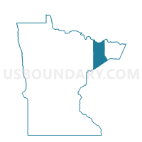
Voting Districts not defined, Lake County, Minnesota
About
Outline

Summary
| Unique Area Identifier | 602873 |
| Name | Voting Districts not defined |
| County | Lake County |
| State | Minnesota |
| Area (square miles) | 700.72 |
| Land Area (square miles) | 0.00 |
| Water Area (square miles) | 700.72 |
| % of Land Area | 0.00 |
| % of Water Area | 100.00 |
| Latitude of the Internal Point | 47.13540740 |
| Longtitude of the Internal Point | -91.28839570 |
Maps


Graphs
Select a template below for downloading or customizing gragh for Voting Districts not defined, Lake County, Minnesota


Neighbors
Neighoring Voting District (by Name) Neighboring Voting District on the Map
- Amnicon - T 9999 Voting District, Douglas County, WI
- Beaver Bay Voting District, Lake County, MN
- Beaver Bay Twp. P-1, Lake County, MN
- Beaver Bay Twp. P-4, Lake County, MN
- Duluth Twp. Voting District, St. Louis County, MN
- Schroeder Twp. Prec. 12, Cook County, MN
- Silver Bay P-1, Lake County, MN
- Silver Bay P-2, Lake County, MN
- Silver Creek Voting District, Lake County, MN
- Two Harbors W-1, Lake County, MN
- Unorg. Terr. No. 1 Voting District, Lake County, MN
- Unorg. Terr. No. 2 Prec. 1, Lake County, MN
- Unorg. Terr. No. 2 Prec. 2, Lake County, MN
- Voting Districts not defined, Cook County, MN
- Voting Districts not defined, St. Louis County, MN
- WATER Voting District, Ashland County, WI
- WATER Voting District, Bayfield County, WI
Top 10 Neighboring County Subdivision (by Population) Neighboring County Subdivision on the Map
- Two Harbors city, Lake County, MN (3,745)
- Lake No. 2 UT, Lake County, MN (2,094)
- Duluth township, St. Louis County, MN (1,941)
- Silver Bay city, Lake County, MN (1,887)
- Silver Creek township, Lake County, MN (1,138)
- Beaver Bay township, Lake County, MN (473)
- Schroeder township, Cook County, MN (205)
- Beaver Bay city, Lake County, MN (181)
- Lake No. 1 UT, Lake County, MN (154)
- County subdivisions not defined, St. Louis County, MN (0)
Top 10 Neighboring Place (by Population) Neighboring Place on the Map
Top 10 Neighboring Unified School District (by Population) Neighboring Unified School District on the Map
- Lake Superior Public School District, MN (13,355)
- Maple School District, WI (7,983)
- Cook County Public Schools, MN (5,176)
- School District Not Defined (Water), WI (0)
- School District Not Defined (Water), MN (0)
Top 10 Neighboring State Legislative District Lower Chamber (by Population) Neighboring State Legislative District Lower Chamber on the Map
- Assembly District 73, WI (54,962)
- Assembly District 74, WI (52,623)
- State House District 6A, MN (36,396)
- State House District 7A, MN (36,323)
Top 10 Neighboring State Legislative District Upper Chamber (by Population) Neighboring State Legislative District Upper Chamber on the Map
- State Senate District 25, WI (162,546)
- State Senate District 6, MN (76,702)
- State Senate District 7, MN (72,235)
Top 10 Neighboring 111th Congressional District (by Population) Neighboring 111th Congressional District on the Map
Top 10 Neighboring Census Tract (by Population) Neighboring Census Tract on the Map
- Census Tract 3701, Lake County, MN (4,471)
- Census Tract 3704, Lake County, MN (3,963)
- Census Tract 105, St. Louis County, MN (3,676)
- Census Tract 4801, Cook County, MN (3,126)
- Census Tract 3703, Lake County, MN (2,432)
- Census Tract 9901, St. Louis County, MN (0)
- Census Tract 9901, Lake County, MN (0)
- Census Tract 9900, Cook County, MN (0)
- Census Tract 9900, Douglas County, WI (0)
- Census Tract 9900, Bayfield County, WI (0)
Top 10 Neighboring 5-Digit ZIP Code Tabulation Area (by Population) Neighboring 5-Digit ZIP Code Tabulation Area on the Map
- 55804, MN (14,592)
- 55616, MN (6,994)
- 55614, MN (2,627)
- 55609, MN (303)
- 55613, MN (205)
- 55601, MN (105)